Many Landmark locations in Zelda Tears of the Kingdom, spanning its Surface, Sky, and Depths. A 100% map completion in Zelda: TotK is one monumental task, taking well over 100 hours to accomplish.
This includes visiting every named location and collecting 1,000 Korok Seeds, which is arduous. This guide will explore every significant landmark in Zelda: TotK and other related details to these locations.
Landmark locations map in Zelda: Tears of the Kingdom
We shall go with Hyrule’s Surface, Sky, and Depths locations by region, making it easy for you to understand where each landmark is located.
Jump To:
Hyrule surface landmark locations in Zelda Totk
The Hyrule Surface alone makes up most of the landmark locations, with 88 Landmarks.
(Southern) Hyrule Field landmark locations

The first area of the game is accessible on the ground to players. However, you need to complete the tutorial on Sky Island first. This sub-region contains 16 landmark locations.
1. Temple of Time Ruins
Temple of Time Ruins can be found on the northern edge of Hyrule Field, near Tadarok Shrine, at -0823, -2031, 0120 coordinates.
2. Outpost Ruins
Outpost Ruins are east of the Great Plateau Tower, near Kamizun Shrine, at -0233, -1678, 0009 coordinates.
3. East Post Ruins
East Post Ruins are located on the western edge of the West Necluda region, southeast of Teniten Shrine.
4. Kolomo Garrison Ruins
Kolomo Garrison Ruins are on a small plateau that projects into the neighboring Lake Kolomo.
5. Gatepost Town Ruins
These ruins are situated near Kyokugon Shrine, west of Owlan Bridge.
6. Owlan Bridge
This bridge is situated on the southeastern part of Hyrule Field, near Tajikats Shrine.
7. Coliseum Ruins
Coliseum Ruins are situated northwest of the Great Plateau, near Riogok Shrine.
8. Aquame Bridge
Aquame Bridge is on Aquame Lake in Hyrule Field, connecting the Coliseum Ruins and the mainlands of Hyrule Field.
9. Manhala Bridge
Manhala Bridge connects two parts of the Central Hyrule region and is near the Great Fairy Fountain at Outskirt Stable.
10. Gleeok Bridge
This Landmark in Zelda Tears of the Kingdom is a small wooden bridge that crosses the Regencia River. It is situated in the west of the Mayachin Shrine.
11. Hyrule Garrison Ruins
These ruins are located southeast of the Central Tower within Hyrule Field.
12. Ancient Tree Stump
Ancient Tree Stump is near Mount Daphness. This landmark consists of a water pond.
13. Sage Temple Ruins
Sage Temple Ruins find their home at the bank of Regencia River, very close to Giant’s Forest.
14. Giant’s Forest
Giant’s Forest is adjacent to Sage Temple Ruins, near River Regencia, at -1177, -0115, 0035 coordinates.
15. Mabe Village Ruins
Mabe Village Ruins are adjacent to Ranch Ruins in the Central Hyrule region. The closest shrine is Jiosin Shrine.
16. Rebonae Bridge
Rebonae Bridge connects Lanayru Wetlands to the upper portion of Hyrule Field and is situated southwest of Jojon Shrine.
(Northern) Hyrule Field landmark locations
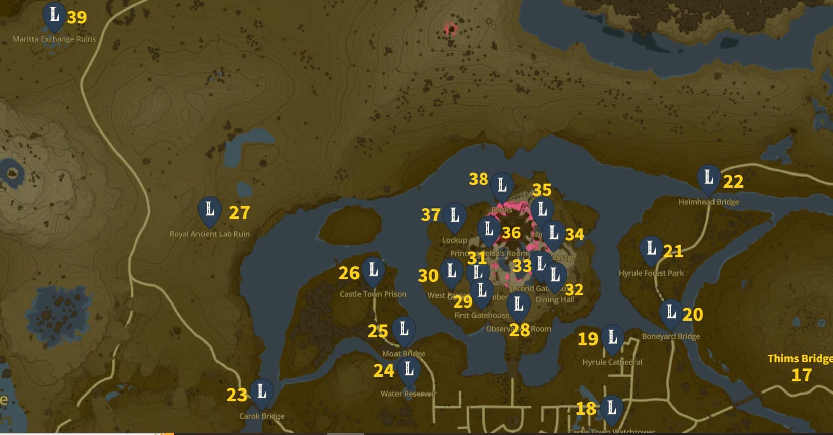
This sub-region contains the most significant number of landmarks, having 23 in total.
17. Thims Bridge
This bridge connects the Hyrule Field with the Eldin Canyon region and is near Jojon Shrine.
18. Castle Town Watchtower
This landmark in Zelda: Tears of the Kingdom is located near Yamiyo Shrine, northeast of Lookout Landing Skyview Tower.
19. Hyrule Cathedral
Hyrule Cathedral is situated on the left bank of the Hylia River, southeast of Hyrule Castle.
20. Boneyard Bridge
Boneyard Bridge is located over the Hylia River, leading to Hyrule Forest Park.
21. Hyrule Forest Park
Hyrule Forest Park is the only landmark on the last Island leading to Eldin.
22. Helmhead Bridge
Helmhead Bridge connects Central Hyrule with the Eldin region. The closest shrine to this landmark is Sepapa Shrine.
23. Carok Bridge
Carok Bridge is located near the fields of Ishodag Shrine and leads to New Serenne Stable.
24. Water Reservoir
Water Reservoir is between Moat Bridge and West Castle Town, Central Hyrule, at -0580, 0527, 0021 coordinates.
25. Moat Bridge
Moat Bridge is located on the northwestern border of the Hyrule Castle Town Ruins, near Kyononis Shrine.
26. Castle Town Prison
Castle Town Prison is located on a separate Island in the northwestern Hyrule Field, near Hyrule Castle Moat West Chasm.
27. Royal Ancient Lab Ruin
Royal Ancient Lab Ruins is situated in the northern part of Central Hyrule, near the Dragon Tear.
28. Observation Room
The Observation Room landmark in Zelda Tears of the Kingdom is just past the bridge of Hyrule Castle Moat, at -0241, 0783, 0042 coordinates.
29. First Gatehouse
The First Gatehouse is situated along the pathway to the Sanctuary in Hyrule Castle. This is also where you find Captain Hoz in Zelda: TotK.
30. West Passage
The West Passage is an obsolete burrow system part of the Hyrule Castle Underground.
31. Guard’s Chamber
Guard’s Chamber landmark is very close to Water Reservoir, Central Hyrule.
32. Dining Hall
Dining Hall is a spacious room closely connected to Second Gatehouse, Central Hyrule region.
33. Second Gatehouse
The Second Gatehouse is a small building on the path to Sanctum that continues to the First Gatehouse.
34. East Passage
The East Passage is an extensive cave in the Hyrule Castle Underground, at -0073, 0987, 0034 coordinates.
35. Library
This landmark in Zelda Tears of the Kingdom is located in the eastern part of the Sanctum. It is also where the Black Hinox mini-boss spawns during Crisis at Hyrule Castle’s main quest.
36. Princess Zelda’s Room
Princess Zelda’s Room is adjacent to Princess Zelda’s Study in the western part of Hyrule Castle, at -0327, 1001, 0186 coordinates.
37. Lockup
The landmark in Zelda: TotK is situated on the path that starts from East Passage. This is where you can find Hylian Shield in Zelda: Totk.
38. Docks
The Docks are in the northernmost part of Hyrule Castle, near Serutabomac Shrine.
39. Maritta Exchange ruins
The Maritta Exchange Ruins are in the northwestern Central Hyrule, near Tanagar Canyon East Cave.
Hyrule Castle landmark locations
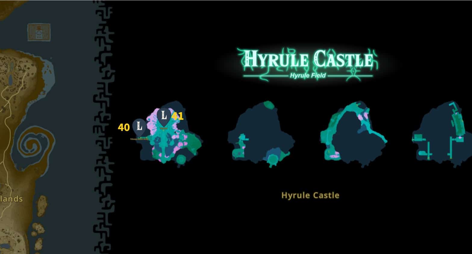
There are only two Landmarks found in Hyrule Castle. It can be visited from the Surface after Link has completed Great Sky Island.
40. Sanctum
The Sanctum happens to be the highest point in Hyrule Castle. It is where Calamity Ganon’s location is shown on your map.
41. Princess Zelda’s Study
This study room is connected to Princess Zelda’s Room by a bridge. It contains Zelda’s Research Notes that have her discoveries.
West Necluda landmark locations

West Necluda is a large plain area filled with ponds and mogs and contains nine Landmark locations.
42. Bridge of Hylia
This Bridge connects the two parts of Lake Hylia, southwest of the Hills of Baumer Chasm, near En-Oma Shrine.
43. Spring of Courage
The Spring of Courage is near Jiukoum Shrine, southeast of Popla Foothills Skyview Tower.
44. Proxim Bridge
The Proxim Bridge connects West Necluda to the Hyrule Field near the Forest of Time Chasm.
45. Horwell Bridge
This bridge is situated in the northwestern part of the Necluda region, near Riverside Stable Well.
46. Eagus Bridge
The Eagus Bridge happens to be on the northern portion of West Necluda and paves the way to Morok Shrine.
47. Floret Sandbar
The Floret Sandbar landmark in Zelda Tears of the Kingdom is situated on a small Island between the northern Hylia River near the Bottomless Pond well.
48. Fort Hateno
It is a deep cave situated on the borders of the East and West Necluda regions.
49. Lanayru Road- East Gate
This landmark in Zelda: Totk is located on the eastern side of Lanayru Road, east of Lanayru Road East Cave, and west of the Jogou Shrine.
50. Lanayru Road- West Gate
This gate is on grassy land, an entrance pathway towards the Lanayru Promenade.
East Necluda landmark locations

The East Necluda region is an isolated area of the Hyrule map. Naydra Snowfield is in its north, separated by humongous mountains, south of the Mount Lanayru region. There are only two Landmark locations in this region.
51. Palmorae Ruins
The Palmorae Ruins are located on the western edge of the Necluda Sea, east of Mount Dunsel Cave.
52. Retsam Forest
This landmark in Zelda: Totk is situated on the southeastern shore of Lake Sumac, near Mayahisik Shrine.
Faron Grasslands landmark locations
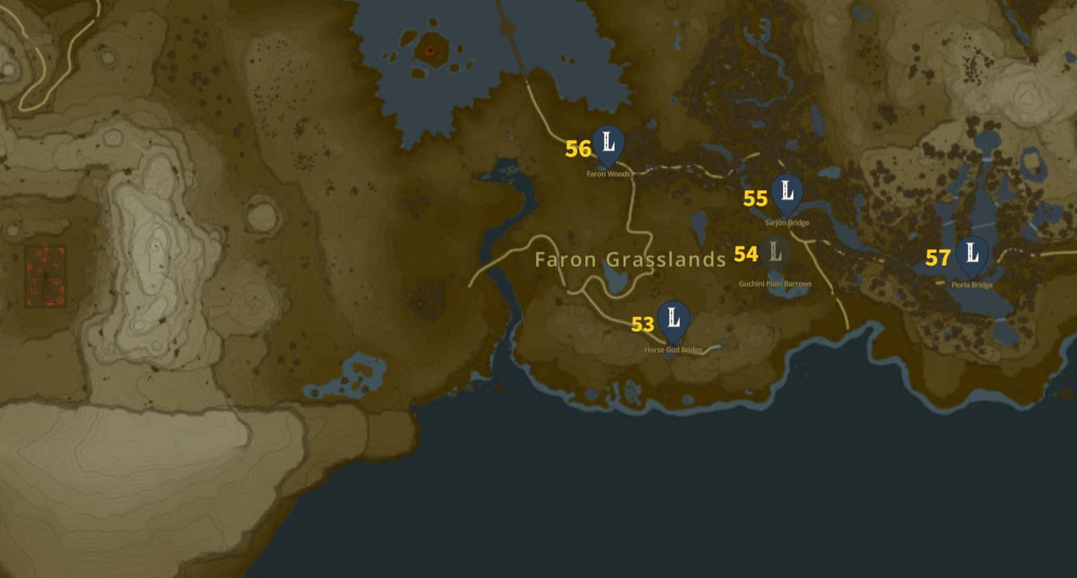
Faron Grasslands region is a vast forest in the Southeastern corner of Hyrule. It is home to Lurelin Village and Eventide Island. Its neighboring region is the Gerudo Desert, situated on the east side.
There are only five landmark locations in this region.
53. Horse God Bridge
The Horse God Bridge is situated over the Lake of the Horse God, north of Komo Shoreline Cave.
54. Guchini Plain Barrows
Guchini Plain barrows are lush green fields beside Herin Lake, south of the Sarjon Bridge.
55. Sarjon Bridge
The Sarjon Bridge happens to be on the northern tip of Sarjon Woods, connecting them to Zonai Ruins. The Sarjon Woods Cave is situated right in the northeast of this landmark.
56. Faron Woods
Faron Woods are adjacent to Finra Woods, just west of Finra Woods Excavation Site.
57. Floria Bridge
Floria Bridge is built over Lake Floria and connects the Ebara Forest with the Ubota Point area. The nearest Shrine of light is Joju-u-u Shrine.
Gerudo Desert landmark locations
Gerudo Desert is an extreme weather area in the southwestern part of the Hyrule map. This region’s hot days and cold nights can bring any player to his senses in a matter of few steps. As you enter the area and get past its Kara-Kara Bazaar, you’ll see that everything beyond that point is barely visible in sandstorms.
The only way ahead is your map, which will still clearly show the region’s topography. Despite being the enormously massive land of Hyrule, the Gerudo Desert consists of only six landmark locations in Zelda Tears of the Kingdom.
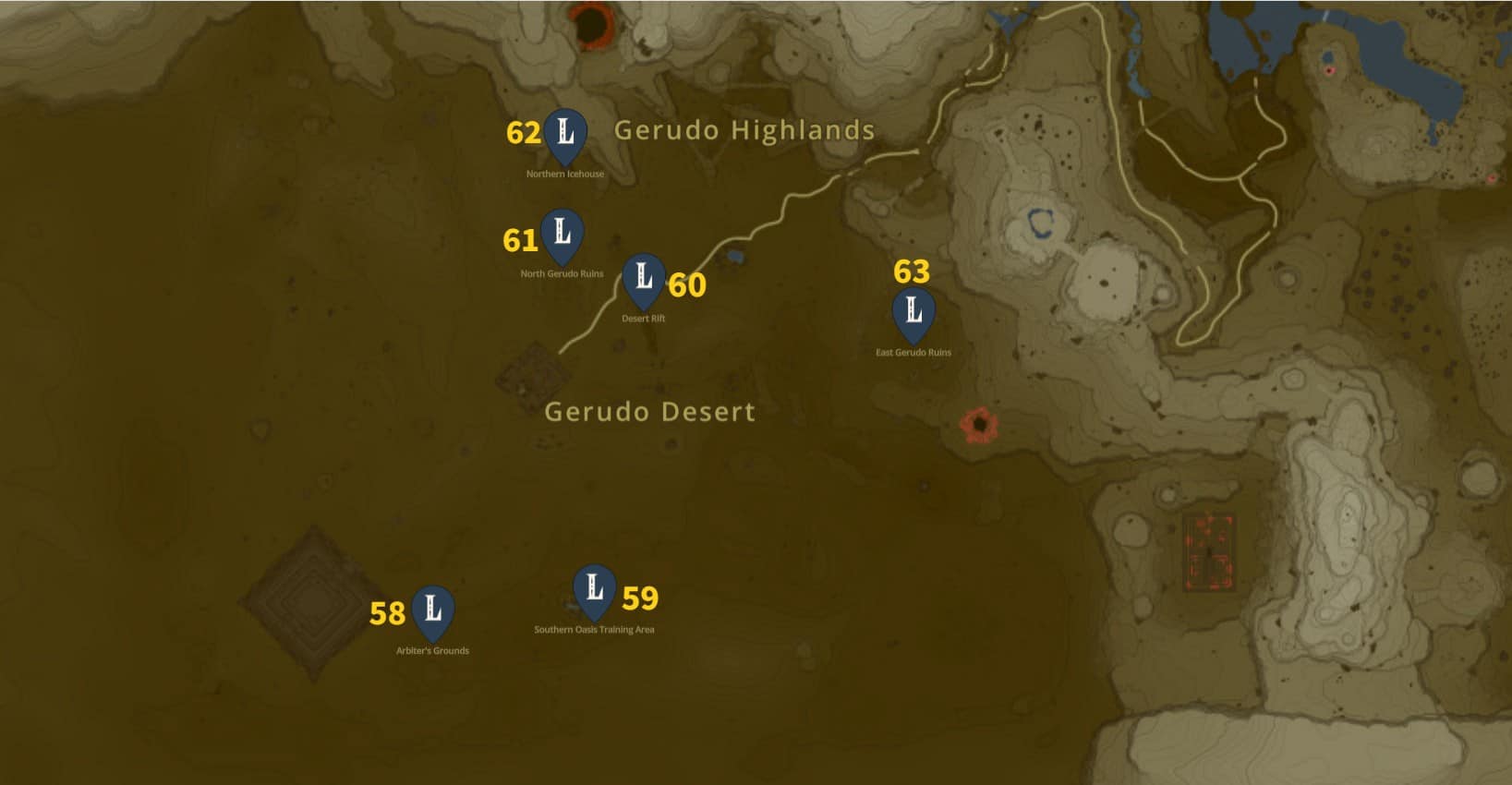
58. Arbiter’s Grounds
Arbiter’s Ground is in the southwestern portion of the Gerudo Desert mainland, near Irasak Shrine.
59. Southern Oasis Training Area
The Southern Oasis Training Area is located at the southern tip of Southern Oasis, near Karahatag Shrine. You can also play the Desert Race mini-game in this place.
60. Desert Rift
The Desert Rift is near the Oasis Source Cave, southwest of the Mayatat Shrine.
61. North Gerudo Ruins
North Gerudo Ruins are near the Northern Icehouse, in the middle of Gerudo Sanctuary.
62. Northern Icehouse
The Northern Icehouse is on the Gerudo Sanctuary’s northern edge.
63. East Gerudo Ruins
East Gerudo Ruins are situated in the eastern portion of the Gerudo Desert, northwest of the East Gerudo Chasm.
Lanayru Great Spring landmark locations

Lanayru Great Spring is one of the eastern regions in Hyrule, located in the Lanayru Province of Hyrule. As such, it is the primary water source for all that lives and breathes in the Hyrule Surface. Its neighboring regions are Mount Lanayru in the south and Akkala Highlands in the north.
There are only three Zelda TotK landmark locations in this region.
64. Oren Bridge
The Oren Bridge is built over the Zora River near Oren Bridge Cave.
65. Luto’s Crossing
Luto’s Crossing is a small bridge that passes over Ruto Lake. It connects Ruto Mountain with the Ralis Pond area.
66. Inogo Bridge
Inogo Bridge is situated over the western narrow streams of the Zora River, right where the river expands into a large water reservoir. The Maoikes Shrine is located in southwest of this landmark.
Lightning Temple Landmark locations

The Lightning Temple is a locked area only accessible after solving the Riddle of Red Pillars at the end of the Riju of Gerudo Town quest. This dungeon-like Temple is where you will encounter Queen Gibdo.
The Lightning Temple consists of four landmarks in Zelda Tears of the Kingdom.
67. Room of Light and Shade
The Room of Light and Shade is on the 4th Floor of Lightning Temple, containing an altar in one of its chambers.
68. Room of Light and Flame
This room is located on the 2nd Floor of Lightning Temple, containing a particular battery in the middle.
69. Room of Ascension
The Room of Ascension is the main puzzle area of the Lighting Temple, containing the Zonai terminal. It is located in the Lightning Temple 1F.
70. Room of Hopeful Light
This room is below the Ascension Room in Lightning Temple B1. This room contains a Light Beam and a light switch needed to reach the room above.
Lanayru Wetlands Landmark Locations

Lanayru wetlands and West Necluda make the central part of eastern Hyrule. This landmark in Zelda: Totk consists of vast plains containing four shrines and one major Landmark.
71. Moor Garrison Ruins are situated on the western bank of the upper Zora River, near Crenel Peak Cave. The Lanayru Wetlands Chasm on Mercay Island happens to be on the opposite side of this landmark.
Hebra Mountains Landmark locations

The Hebra Mountains are a cold region located northeast of Tabantha Frontier. The harsh climate of this region demands players to equip cold-resistant armor and food items for easy survival. The infamous Abandoned Hebra Mine is also situated in this area, where some proceedings of the Master Kohga of the Yiga Clan’s main quest occur.
There are two Landmark locations in the Hebra Mountains region.
72. Sherfin’s Secret Hot Spring
This hot spring is located in the northwestern portion of the Hebra Mountains region, west of Hebra North Summit.
73. North Lomei Labyrinth
The North Lomei Labyrinth is in the northeastern part of the Hebra Mountains. You can also reach here by going West from Eldin Mountains. The Mayaotaki Shrine and North Lomei Chasm are located in this map area.
Tabantha Frontier Landmark locations

Tabantha Frontier is adjacent to the Hebra Mountains, located northwest of the Hyrule Ridge. There are only two landmarks that can be spotted in this area,
74. Dragon Bone Mire
Dragon Bone Mire is situated a few steps away from Lake Totori. It can be accessed from Passer Hill as well as from the northern side where Wao-os Shrine is located.
75. Tabantha Great Bridge
The Tabantha Great Bridge is located southwest of Mount Rhoam, near the Tabantha Bridge Stable Well.
Eldin Mountains Landmark locations

Eldin Mountains is a long mountain range that constructs the northwestern portion of the Eldin region. This area consists of tall hills, cliffs, and barren wastelands.
There is only one landmark situated in this mountain range.
76. Eldin Great Skeleton
The Eldin Great Skeleton is located in the northern Eldin Mountains. It is the location where Link has to go to complete Eldin’s Colossal Fossil Side Quest.
Hyrule Ridge Landmark locations

The Hyrule Ridge is a mountainous area in the west of Hyrule Field. The Thundra Plateau and Ludfo’s Bog are some of the notable areas in this region. Two landmarks can be found in Hyrule Ridge.
77. Sanidin Park Ruins
Sanidin Park Ruins are located on the western bank of the Regencia River and can be spotted by walking on the path that starts from Manhala Bridge and goes to Nima Plain.
78. Jeddo Bridge
The Jeddo bridge is built over the water body comprising the intersection of Regencia River and Tamio River. It connects the two split parts of Hyrule Ridge.
Akkala Highlands Landmark locations
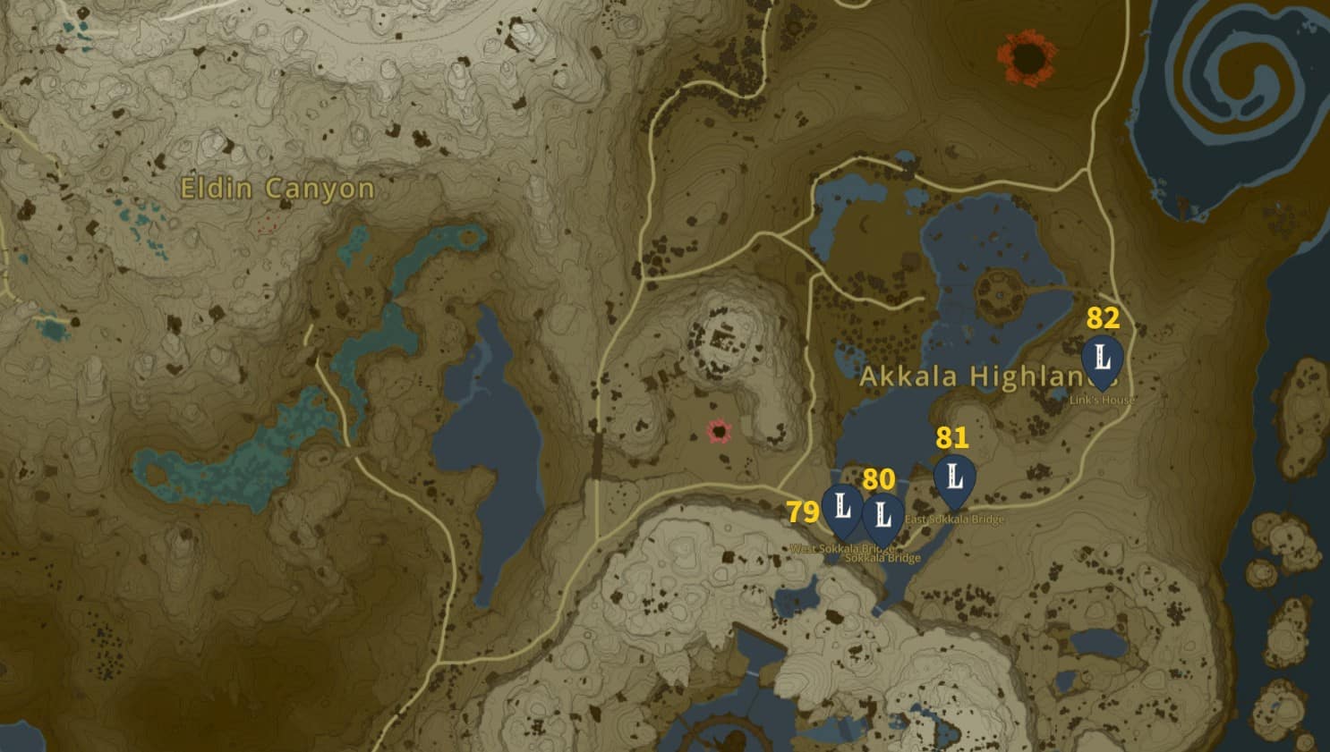
The Akkala Highlands form the southeastern corner of the Akkala region, touching the vast waters of the Akkala Sea and Lanayru Great Spring. This region is a dense forest where the fall of the Hyrule Kingdom started, despite it being the defensive region of the kingdom.
Akkala Highlands consists of four landmark locations.
79. West Sokkala Bridge
This landmark is right over the South Akkala Lake, connecting it to the Akkala Parade Ground Ruins.
80. Sokkala Bridge.
The Sokkala Bridge is to the south of West Sokkala Bridge. It spans the whole central part of Lake Akkala.
81. East Sokkala Bridge
East Sokkala Bridge is built over the eastern portion of Lake Akkala and connects it to the Kaepora Pass area.
82. Link’s House is close to Ulri Mountain in the Akkala Highlands. You can spot Ulri Mountain Skyview Tower by walking a few steps to the mountain.
Deep Akkala Landmark locations

The Deep Akkala region forms the northern portion of Akkala and borders the Death Mountain in the west. There are three landmarks in this region.
83. Spring of Power
The Spring of Power is west of East Akkala Stable, north of Ordorac Quarry. You can look for this spring at these coordinates (3855 2685, 0050).,
84. Gut Check Rock
It is a giant rock structure inside a water body west of Skull Lake. The nearest Shrine of Light happens to be the Kimayat Shrine, located on the northeastern side.
85. Lomei Labyrinth Island
Lomei Labyrinth Island is situated in the northeastern corner of the Hyrule map. It is accessible from the Akkala land area by gliding down to its entrance.
Eldin Canyon Landmark locations

Eldin Canyon is in the northeast part of the Hyrule map. It borders with Akkala region in the east and Great Hyrule Forest in the west. The infamous Death Mountain and Goron City are also parts of this region.
There are only two landmark locations to be visited in Eldin Canyon.
86. Bridge of Eldin
The Bridge of Eldin is a metal drawbridge that crosses the Death Caldera and connects Death Mountain with other Eldin region areas.
87. Death Mountain West Site
Death Mountain West Site is on the western part of Death Mountain. The nearest shrine you can spot is Sitsum Shrine (coordinates 2369, 2596, 0804)
Gerudo Highlands Landmark location

The Gerudo Highlands region forms the northern portion of the vast Gerudo Desert. This map area is full of sandy plains and hot weather, where Yiga Clan ninjas can be seen roaming around.
There is only one landmark you can spot in this region.
88. Mount Agaat Mount Agaat is situated in the northwestern part of the Gerudo Desert. It is the only named location in the game that cannot be accessed. You can go under it but won’t be able actually to climb its high hills.
Hyrule Sky Landmark locations in Zelda TotK
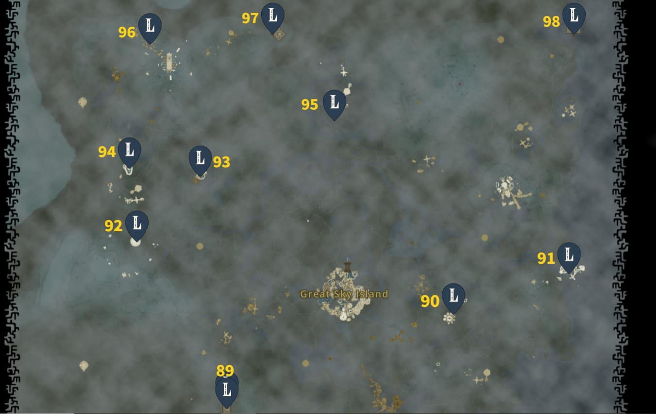
The Hyrule Sky consists of ten Landmark locations. All of these are listed below.
89. South Lomei Castle Top Floor
South Lomei Castle’s Top Floor is situated on the South Lomei Castle and can be accessed by jumping from Gerudo Canyon Skyview Tower into the skies. The Siyamotsus Shrine (coordinates -1795, -3295, 1025) is located on the northern corner of this castle.
90. Zonaite Forge Island
The Zonaite Forge Island is in the North Necluda Sky Archipelago, above the Kakariko village.
91. Valor Island
Valor Island is located in the South Lanayru Sky Archipelago and can be accessed by starting your journey from Mount Lanayru Skyview Tower.
92. Starview Island
Starview Island is situated in the North Gerudo Sky Archipelago. The Mayasiar Shrine (coordinates -3547, -0321, 1979) is located in the western corner of this small, isolated island.
93. Courage Island
Courage Island is located in the Tabantha Sky Archipelago at -2402, 0825, 0629 coordinates. After unlocking Lindor’s Brow Skyview Tower, you can easily access this Island where Taunhiy Shrine is also situated.
94. Lightcast Island
This Island is located in Tabantha Sky Archipelago and can be accessed using Lindor’s Brow Skyview Tower. The Ga-this shrine can be spotted in the southern corner of this area,
95. Bravery Island
It is a small Island in the North Hyrule Sky Archipelago, where the Simosiwak shrine can also be visited. The easiest way to reach this Island is by launching yourself from Thyphlo Ruins Skyview Tower.
96. Rising Island Chain
As the name suggests, this is a chain of small rocky Sky Islands where Kahatanaum Shrine is located. It is located in the Hebra Sky region.
97. North Lomei Castle Top Floor
This landmark is on the North Lomei Castle, a Labyrinth in the Hebra Sky region. You can also spot Tenbez Shrine at the edge of North Lomei Castle’s Top Floor.
98. Lomei Sky Labyrinth
Lomei Sky Labyrinth is situated in the Akkala Sky, at the northwest corner of the map. To reach this landmark in Zelda: TotK, you must launch yourself from the Ulri Mountain Skyview Tower and cover a long airborne distance before going to this Sky Labyrinth in Zelda: TotK.
Hyrule Depths Landmark locations in Zelda TotK
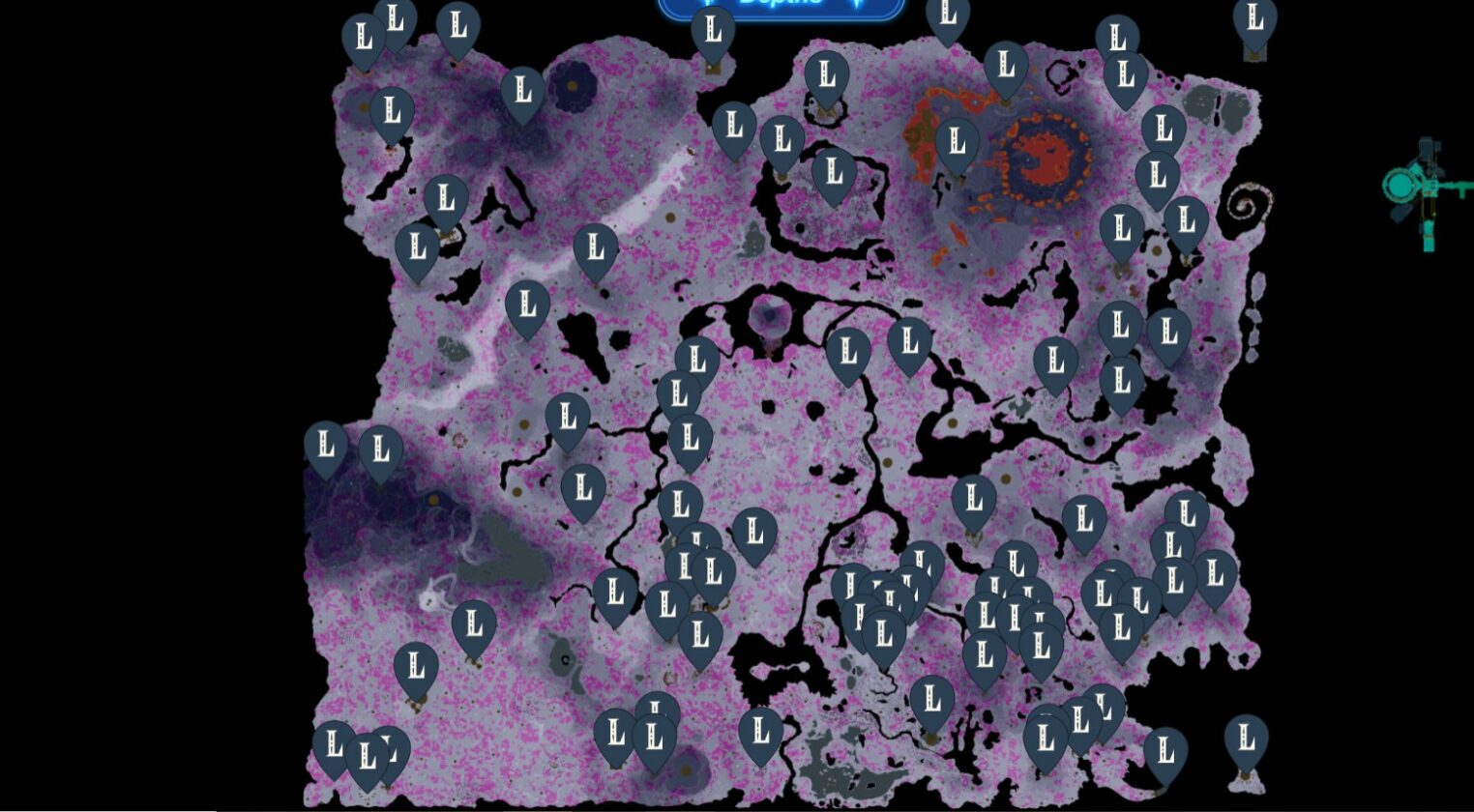
The Depths in Zelda: TotK are a completely different underground realm. Players can access areas in these Depths through dark portals called Chasms.
99. Lone Island Coliseum
The Lone Island Coliseum landmark in Zelda Tears of the Kingdom is below Eventide Island. The precise coordinates of this Island are 4614, -3561, and -0472.
100. Cresia Pit Mine
Cresia Pit Mine is directly below Soka Point of Faron at 3794-3613-0445 coordinates. The closest fast travel point to this location is Mimufis Lightroot.
101. Tuft Canyon Mine
This mine is directly underneath Tuft Mountain, at 2520, -3602, -0626 coordinates. You can also get your hands on Cap of the Hero from Hero Armor.
102. Abandoned Lurelin Mine
This mine is underneath Lurelin Village at 2907, -3413, -0453 coordinates. The nearest fast-travel point is Mimufis Lightroot.
103. Dunsel Canyon Mine
Dunsel Canyon Mine is directly below the Dunsel Plateau, at 3139, -3269, -0642 coordinates.
104. Ebon Canyon Mine
Ebon Canyon Mine is underneath Ebon Mountain at 2907, -3413, -0453 coordinates.
105. Midla Grove
Midla Groive is directly below Midla Woods at 3108, -2204, and -0505 coordinates.
106. Abandoned Hateno Mine
This mysterious mine is underneath Hateno Village, at 3587, -2162, -0596 coordinates. The nearest fast-travel point to this location is Kimnaz Lightroot.
107. Retsam Grove
Retsam Grove is northeast of Ginner Grove, at 3859, -2040, -0644 coordinates. The nearest fast-travel point happens to be Kisihayam Lightroot.
108. Walnot Canyon Mine
This mine is in the eastern part of East Necluda Depths, at 3859, -2040, -0645 coordinates.
109. Canyon of Awakening Mine
This mine is in Eldin Canyon Depths, at 3023, -1372, -0727 coordinates.
110. Taran Canyon Mine
This landmark location is below Taran Pass, in East Necluda Depths. The nearest fast travel point to this mine is Yikot Lightroot.
111. Meda Canyon Mine
This mine is situated under the rocky structures of Meda Mountain. Traveling through Meda Mountain Chasm is the best way to get to this area.
112. Spirit Temple
The Spirit Temple is one of the seven dungeons in Totk, part of the Guidance from Ages Past quest. It is below Faron Grasslands Depths at 1419, -3170, and -0619 coordinates.
113. Floria Canyon Mine
Floria Canyon Mine is located beneath Mount Floria, where Blue Hinox can be encountered.
114. Secluded Coliseum
The Secluded Coliseum is north of Meda Lavafalls, in East Necluda Depths. The purple Ravio’s Hood can be obtained by visiting this landmark.
115. Abandoned Kakariko Mine
The Abandoned Kakariko Mine is a part of the Depths directly underneath Kakariko Village. The closest fast-travel point is the Arusakam Lightroot.
116. Dueling Canyons Mine
This mine is a part of the Dueling Peaks Depths, located north of Sohse Lightroot. You can get your hands on Tunic of the Hero by visiting this mine.
117. Dracozu Altr
The Dracozu Altar is adjacent to the Wellspring of Courage and part of the Dracozu Lake Depths. The nearest fast-travel point is Sijotu Lightroot.
118. South Lomei Depths Labyrinth
This perplexing Labyrinth is situated in the East Gerudo Depths area and has Sisustom Lightroot. This is also where the adventurous encounter with Flux Construct III occurs.
119. Grove of Time
The Grove of Time is situated directly underneath the Forest of Time and is part of the southern Hyrule Depths.
120. Faloraa Canyon Mine
Faloraa Canyon Mine is located in the western Depths of Mount Faloraa. You can encounter a regular Frox by walking a few steps south of this mine.
121. Great Abandoned Central Mine
The Great Abandoned Central Mine is underneath Great Plateau, at -0822, -194 1-0523 map coordinates. This is where you come after accepting A Mystery in the Depths quest and consequently fighting Master Kohga for the first time.
122. Hylia Canyon Mine
Hylia Canyon Mine is right below Mount Hylia, east of Koradat Lightroot. This is where you can obtain Miner’s Trousers.
123. Abandoned Gerodu Mine
The Abandoned Gerudo Mine (coordinates -3815, -2952, -0487) is in the central Gerudo Desert Depths, near Gonatoyros Lightroot. This is where Master Kohga of Yiga Clan fights you for the second time, resulting in his defeat and fleeing from the scene.
124. Abandoned Kara Kara Mine
The Abandoned Kara Kara Mine is beneath North Gerudo Depths at -3196, -2508, -0475 coordinates. The closest fast-travel point to this location is Tatayam Lightroot.
125. Abandoned Lanayru Mine
This mysterious mine is underneath Zora’s Domain in the Lanayru Great Spring Depths region. This landmark in Zelda’s Tears of the Kingdom is the place where Master Kohga fights you in a boat, as he’s already done fighting you on the ground as well as in the air. Unfortunately, Kohga gets to escape from the scene and warns you about your final encounter at his place.
126. Gerudo Canyon Mine
Gerudo Canyon Mine is situated east of Agaat Canyon Mine, in the Depths of Gerudo Summit. Mustuto Lightroot happens to be the nearest fast-travel point to the mine.
127. Daphnes Canyon Mine
This mine is located below Mount Daphnes at -1077, -0557, and -0514 coordinates in the western Depths of Hyrule Field.
128. Lindor Canyon Mine
Lindor Canyon Mine is situated below Lindor’s Brow in the northern Depths of the Hyrule Ridge region. Its nearest fast-travel point is Nabahi-ikat Lightroot.
129. Cuho Canyon Mine
This landmark in Zelda: TotK is in northwestern Tabantha Frontier Depths, at -3789, 1344, -0682 coordinates. The nearest lightroot happens to be Kataki Lightroot.
130. Abandoned Hebra Mine
Abandoned Hebra Mine is in central Tabantha Frontier Depths, at -3653, 1807-, 0438 coordinates. One easy way to reach this mine is by traveling through Hyrule Ridge Chasm. This mine is where you engage in one last and final battle with Master Kohga.